Construction Underway on Bicycle Pathways and Pedestrian Improvements
Bicycles are one of the quickest ways to get downtown from the Westside, and the City of Santa Barbara is working on a clear and safe route that extends all the way to Milpas Street. In addition to clearly marked bicycle paths, new pedestrian improvements on the Westside will include crosswalks, street lighting, realigned traffic signs, and speed humps to slow car traffic.
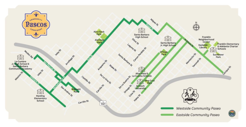
At its farthest points, the new biking route will begin at Gillespie and Mission streets and run in a zig-zag pattern across town to Nopal and Canon Perdido streets, where it will join up with a pathway also under construction on the Eastside. A new line of bollards, like the black chess pieces that mark the State Street Promenade, will separate cyclists from traffic across the Micheltorena Bridge to Castillo Street.

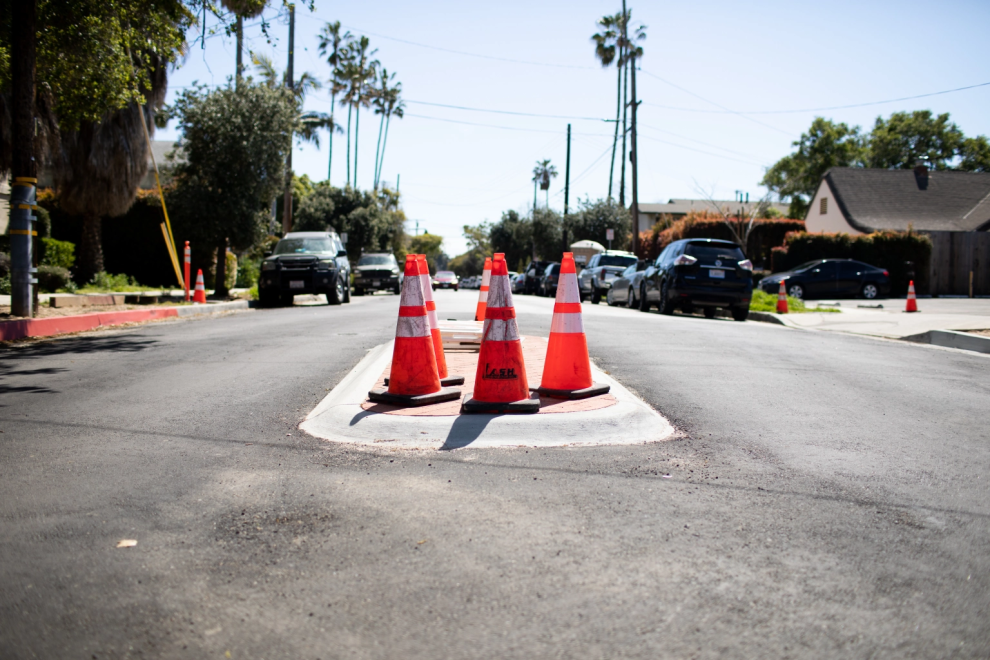
Within the Westside, Gillespie and San Pascual are designated “bike friendly streets,” explained the city’s bike traffic czar Jessica Grant. Stop signs will be realigned to let traffic flow along the two narrow streets from Mission to Anapamu, with landscape peninsulas — raised speed humps occasionally in between two tree planters — on certain blocks to decrease speeding.
New four-way stops will crop up at major intersections, and new traffic diverters — brick medians that allow bicycles to filter through — will be implemented at Mission, Sola, and Valerio intersections. All of Gillespie will be a class III bike lane, with green bicycle “sharrows” to indicate the bike route and remind drivers to share the road.

One of the biggest community concerns is at Mission, San Pascual, and Modoc Road, where cars headed for the highway meet kids going to school. A new one-block bike path and a set of raised islands should help bicycles and pedestrians get through left-hand turn dangers, to a big set of crosswalks and the Modoc bike path.
Another area residents wanted resolved was Micheltorena and Almond Avenue by Super Cuca’s. Derrick Bailey, a city traffic engineer, explained that Almond was narrow but high in traffic; there was little room for cyclists. To remedy this, a raised median and a crosswalk would restrict left turns — cutting down vehicle traffic — and provide a safe refuge for bikers and pedestrians crossing the road.
Parking is a daily struggle in the area, and residents staunchly rejected most parking removal proposals during community workshops. To avoid solutions like one-way streets or protected bike lanes, the various new medians and speed humps reduced the need to remove parking spots. Nonetheless, about 13 parking spaces were lost on the Westside, while a few may be added.
On Castillo, a one-way street that meets the Micheltorena bike path, 13 parking spaces were sacrificed for a bike lane that goes against the flow of traffic. The lane allows cyclists coming from downtown to avoid Bath Street, which has no bike lane.


Heather Deutsch, executive director of MOVE Santa Barbara County, highlighted that a safe and efficient biking route is part of an equitable transportation system that allows for walking, biking, and driving. In response to irritable NextDoor posts about this project being anti-car, Deutsch stated: “Driving is bad for climate change, bad for air quality, for walkers and bikers, and it’s also very expensive to build driving facilities. Driving takes up a lot of space and it’s not moving many people…. This project will help balance that.”
The Westside Community Paseos Project grew from Santa Barbara’s 2016 Bicycle Master Plan and is consistent with the Vision Zero Strategy which aims to eliminate all traffic related fatalities and injuries in Santa Barbara. Funded by an Active Transportation Grant, which is geared toward projects that increase walking and biking, the Westside Project will cost $4.5 million. The construction is taking place in phases, and has seen recent weather delays, but is projected to last eight more months.
Source : Santa Barbara Independent


